LoginLogin
Might make SBS readonly: thread

Map to DATA

Root / Submissions / [.]

kitesinpowerlinesCreated:
Download:LDEXW3Z4
Version:2.0Size:
If you use the default Smile Tool map editor, you'll know it saves large files. This program aims to take all or individual map layers and export them into PRG3 as DATA instructions with the "WriteMap" function and redraw the entire map with that DATA in the "DrawMap" function. This saves more space than saves from the Smile Tool and produces the same results. All layer data can be exported into a single file as well. This tool is intended to be used to reduce the file size from existing DAT files produced by the Smile Tool map editor. I may or may not create a map editor with these functions integrated in the future.

Instructions:

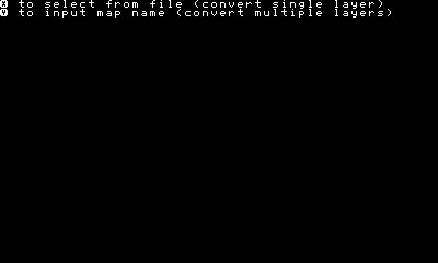
Copy either your map DAT:SC_ files into this program folder or copy READMAP into your own program. Run the READMAP program. Choose one of the following:
  • Choose from fileThis option is best for converting individual layers. Choosing this option will give you a drop down to select a single file. Only SC_ saves are compatible.
  • Input file nameThis option allows you to input the name of your map and convert all layers simultaneously (if SC_ saves exist). You must exclude the file type and layer number part of the file name. As an example, only input the bold: DAT:SC_TESTMAP_L0
Choose whether or not you want to test the output of the map data (this dialog box still prompts, even if you've input the file name incorrectly, this may be corrected in a minor update in the future) Manually save the generated code in PRG3 and copy into your program folder if necessary. Copy the "DrawMap" and/or "Test" function into your program.
usage
DrawMap LabelNameString$, Layer number, 64
You may edit this program into a FOR loop to draw multiple layers simultaneously or use included function
Test LabelNameString$, 1'if global variable SIZE%=64
There are included map files for testing if you wish to use them.

Notes:

Revisions

Version 2.0

  • Changed the WriteMap function to export tile data, x and y location so that empty spaces are not exported
  • Changed the DrawMap function to accommodate the WriteMap function
  • Added the option to input the map name to convert all layers simultaneously

Version 1.0

  • Initial release

Wow... 27 minutes ago... this is completely irrelevant.

Replying to:rando
Wow... 27 minutes ago... this is completely irrelevant.
When I looked at the third picture, I though "INSTANT GAME INSPIRATION!" Cool.

Replying to:rando
Wow... 27 minutes ago... this is completely irrelevant.
Wait did someone else release something like this because I missed it

Replying to:rando
Wow... 27 minutes ago... this is completely irrelevant.
It was definitely 43 minutes ago. This is a smart concept. It could save a lot of room and memory. It will be cool when you implement a map editor.

Replying to:rando
Wow... 27 minutes ago... this is completely irrelevant.
Yes. I am currently looking at other map editor code to learn more about creating one myself. But itโ€™s going to be a while before it is complete, so in the meantime, existing map editors will have to be used and the manual process from the listed steps followed. It is inconvenient but Iโ€™ve gotten some use of these functions in their current state and figured someone else may too.

Replying to:rando
Wow... 27 minutes ago... this is completely irrelevant.
Hopefully you aren't planning on stealing my up to this point unannounced game, Arctic Adventure because I've decided to revive it after my 3DS Data was essentially wiped (only got as far as the title screen anyway) In fact, i'm calling creative commons right now (Just kidding, someone's probably used the name Arctic Adventure before)

Replying to:rando
Wow... 27 minutes ago... this is completely irrelevant.
Coo, coo. Woah. Toad we posted at the same time.

Replying to:rando
Wow... 27 minutes ago... this is completely irrelevant.
Cool, cool.

Replying to:rando
Wow... 27 minutes ago... this is completely irrelevant.
Lol no worries, the sample map included is actually from an RPG Iโ€™m working on and the image here just shows the top left corner of the continent (however, you can see the whole continent in the example file provided)

Replying to:rando
Wow... 27 minutes ago... this is completely irrelevant.
I was actually talking to random_guy.

Replying to:rando
Wow... 27 minutes ago... this is completely irrelevant.
Well this is awkward

Replying to:rando
Wow... 27 minutes ago... this is completely irrelevant.
Nah, I'm working on Ruebled. I will probably add an arctic part of the world map. I might be an idiot and make the overworld maps huge. Yes, I said maps, I'm planning on having 3 overworlds split into sections. The amount of sections in each overworld will be a perfect square (4,9,16,ect.) so that the overworld will be a square (duh.) I should probably be saying this in my thread. I'll copy it to the thread.

I didn't realize this before, but the "WriteMap" function also exports empty spaces which can significantly increases the size of the file. I will experiment with exporting tile data, x location, y location for all used space. If this method further reduces the file size from the exported example map, I will make this update before the map editor update.

This doesn't work for me. i tried to convert a file with no water tiles in it but it got changed to ONLY be water tiles.

Replying to:IAmRalsei
This doesn't work for me. i tried to convert a file with no water tiles in it but it got changed to ONLY be water tiles.
I will look into it